About I-44
The primary purpose of this website concerning the proposed I-44 is to catalog information for any interested party to see. Our focus is the El Paso / Cd Juarez region, but we want to include cities between Phoenix AZ and St Louis MO about the I-44 corridor project over time.
This I-44 corridor concept should be a government project that should be hosted by transportation officials and other stakeholders much like found with the Ports to Plains Alliance. A recent article shows what progress has been made. It will be seen over time if the I-44 from St Louis to El Paso concept will ever be adopted.
We are glad to host information about it until TxDOT El Paso makes considerable moves to pursue it in the future. Until then, this website will serve to promote the concept of the I-44 corridor between St Louis MO and El Paso TX. CVCS also believes that we have found a tool that could potentially accelerate the use and growth of constructing the proposed I-44 between El Paso and Wichita Falls TX. And further, ignite growth along the existing I-44 interstate freeway.
I-44 Elements |
GO TO TOP |
First, I-44 is a primary element. We don’t see this as just an interstate highway, we see more. An interstate highway by one definition is two lanes separated by an island space of some distance before reaching the other two lanes that run in the opposite direction. It is also limited in access.
Part of the existing freight lanes already built in Texas are split highways as described above except not limited access. The same freight lane highway that makes up most of the proposed I-44 Texas route would have to add highway frontage roadway to intercept intersecting farm roads. This process would then require greater grade separation and interchange for travel across the freeway via the use of an overpass for the main freeway over traffic that traverses the freeway below. This would require building new overpass interchanges in some of the more remote areas of North Texas along this proposed I-44 route while other areas mainly south towards I-20, are more difficult and numerous to build new overpass interchanges.
One of the advantages of this proposed I-44 segment from El Paso to Wichita Falls is that many rural miles already have split highway lanes that run at 70 mph. What is required is organization of mainlane access, frontage road access, and intersection overpasses that must be built into the system. Then there is the new construction of split lane limited access around the towns along this proposed I-44 that presents the greatest cost and challenge.
Element North Central Mexico to Midwest Heartland
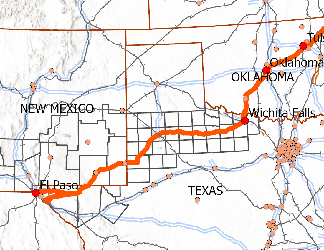
This corridor route from Saint Louis to Tornillo port of entry appears as a natural non-stop freeway on a map. We conclude that it is the most direct Midwest feeder into St Louis on their way to Central North Mexico, I-10, and Phoenix, and to the northern Mexico coastal ports. El Paso already serves as an important port of entry behind the cluster of ports in the Texas Lower Valley. Yet El Paso, being further west is a gateway into northern Mexico and access to west coast Mexico ports and west coast cities.
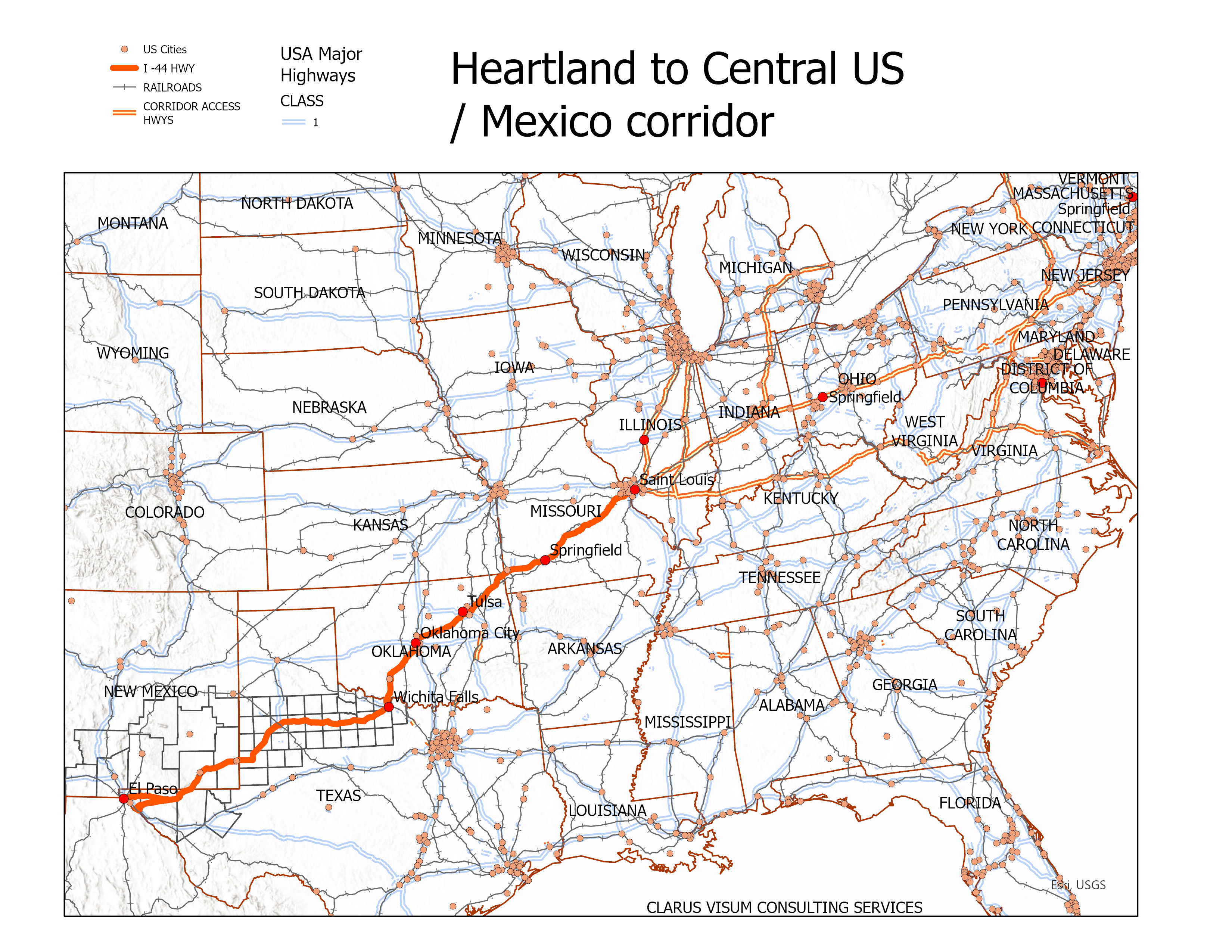
As part of a study — US-Mexico Commerce: Tracking the Final Destination and Mexico’s Fiscal Benefit with Greater Border Efficiency, the “Atlantic Council collaborated with the University of Texas at El Paso’s Hunt Institute for Global Competitiveness and El Colegio de la Frontera Norte to publish a two-part study analyzing the economic impact of a 10-minute reduction in wait times at the US-Mexico border,” which shows an important existing Midwest connection in El Paso regional trade. Just over 25% of El Paso port of entry trade comes from the Midwest, based on the “Final Destination Areas” table found in the study (page 7).
This proposed I-44 corridor is intended to fortify this El Paso to the Midwest relationship and create a direct permanent linkage to the Midwest.
Element Port of Entry
In our proposed route, it was by coincidence that we routed our I-44 through Hueco mountains and directly to Tornillo Tx. This route takes it through the Borrego draw in Hudspeth County where existing paths make it to El Paso County that connects to Fabens Tx. The intent of the Central North Mexico to Midwest Heartland was to connect this corridor to a port of entry. So, I-44 could become one of few interstate highways directly connected to a U.S port of entry along the U.S. / Mexico border.
Using a Bureau of Transportation Statistics visualization tool with 2023 data Port Ranking, Texas lower Valley is highly active and competitive compared to the El Paso Region (See I-44 resources page). Several US Texas Lower Valley ports along the border and a large industrial center in Monterey Mexico provides a highly competitive environment.
This activity is supported by new interstate highways in which the El Paso region has not seen since the inception of the Interstate highway system. The proposed I-44 corridor is in response to utilize an existing interstate freeway that currently terminates in Texas for no rational reason. The extension of the proposed I-44 through Texas northern region and New Mexico allows interstate commerce to flow naturally from Midwest to Southwest border region.
Element Promote Cd Juárez
The El Paso region is fully aware of Cd Juárez and Chihuahua creating jobs in the El Paso / New Mexico region due to their growth as manufacturing hubs. The Inland Port of Tornillo continues this economic growth in Cd Juárez. Chihuahua is competing with other states and the El Paso region needs to take those steps on the U.S. side that creates greater competitive environment for the state of Chihuahua and Cd Juárez in particular. El Paso region economic development, infrastructure, and growth is Cd Juárez’s gain. Cd Juárez gain is El Paso’s gain.
The Upper Rio Grande Valley is anchored by one MSA – El Paso, while the Lower Rio Grande Valley is anchored by four MSAs; the Brownsville-Harlingen MSA, the Corpus Christi MSA, the Laredo MSA, and the McAllen-Edinburg-Mission MSA. The Upper Rio Grande Valley competes with 3 of them for international trade and Cd Juárez competes with Monterey.
Building infrastructure and new connectivity in rail, highway, and generally all other types of networks can help Cd Juárez locally. What the El Paso region can do to make Cd Juarez more competitive is the same as helping the El Paso region grow competitively. Chihuahua City, another great economic anchor helps with Cd Juárez make it a highly competitive state to do international trade which must be promoted, maintained, and assisted by the El Paso region.
The proposed I-44 connected to a port of entry expands the Cd Juárez regional growth and connectivity.
West and East El Paso anchors
Santa Teresa is a considerable competitor in the El Paso region with good geographic features, availability of land, and an important asset to the state of New Mexico as a primary economic development site.
The Inland port of Tornillo can be an El Paso County twin to Santa Teresa. Both with available land, growing infrastructure resources such as rail, electrical power grid, and roadways. Growth between these two important ports of entry surrounds El Paso with two industrial clusters in the future. A case can be made that the inland port of Tornillo will cannibalize industrial economic development away from El Paso. While this can be true to some degree, the greater threat is the regional growth of the Lower Rio Grande valley which will minimize the El Paso growth if the El Paso / Cd Juárez region does not continue to innovate. But more importantly, is that the proposed I-44 corridor accelerates new Midwest trade.
The Inland port of Tornillo can compete with Santa Teresa for industrial and manufacturing companies if they can grow the energy infrastructure, rail into Mexico, and new roadways.
Upper Rio Grande Economic Development
The distance between El Paso downtown and Tornillo is similar to the distance between Tornillo and Esperanza TX as Interstate 10 begins to travel eastward into the mountain region and away from the river Rio Grande valley. Tornillo is closer to Upper Rio Grande valley residences with quick access to I-10 to reach jobs created by the Inland Port of Tornillo development.
For several decades, the Upper Valley region around El Paso and Hudspeth County could create industrial jobs coming from the inland port of Tornillo for nearby small rural towns. This could be an opportunity to expand jobs and income growth to these existing communities.
Element Lib. De Cd Juárez
This is the roadway that connects to highway 45D, as it is currently named, that encircles Cd Juárez from Tornillo to Santa Teresa as a proposed continuous highway. The planning of Lib. de Cd Juárez has been in the planning stage for several years to connect to the Tornillo port of entry. While both the port of Tornillo and the new road in Mexico needs to see growth, the proposed I-44 is a natural addition to these existing infrastructure assets. Not only can congested roads be avoided, but learning from the current ports of entry, what could be done differently? Where neighborhoods and industrial parks are built, can they be better developed?
Sub Element Lib. de Cd Juárez Port
Although we call the entry points between El Paso and Cd Juarez ports of entry, they enter no port other than the area around customs. As should Tornillo build an inland port, so should Cd Juarez. The significance and impact of a Cd Juarez port may be greater than a USA port on the opposite side of the Cd Juarez border. It possibly offers greater opportunities than the U.S side in either Santa Teresa NM or Tornillo TX.
Element Inland Port of Tornillo |
GO TO TOP |
-
Although can be considered a sub element to I-44, the enormous impact of the inland port of Tornillo stands out as a major element. The port is defined mostly by a split I-44 freeway which incorporates the idea of a “split” and “control access” concept in a more extreme way.
Shown on our version of I-44 map approaching Tornillo is two highways or I-44 N and I-44 S as I-44 approached Fabens and I-44 leaves Tornillo. The split freeway normally is within 50 feet from one directional lane to the other. In this case, the maximum split of I-44 is under 6 miles.
Mostly vacant land, limited access would have to be enforced now on the roads built where it eventually can become I-44.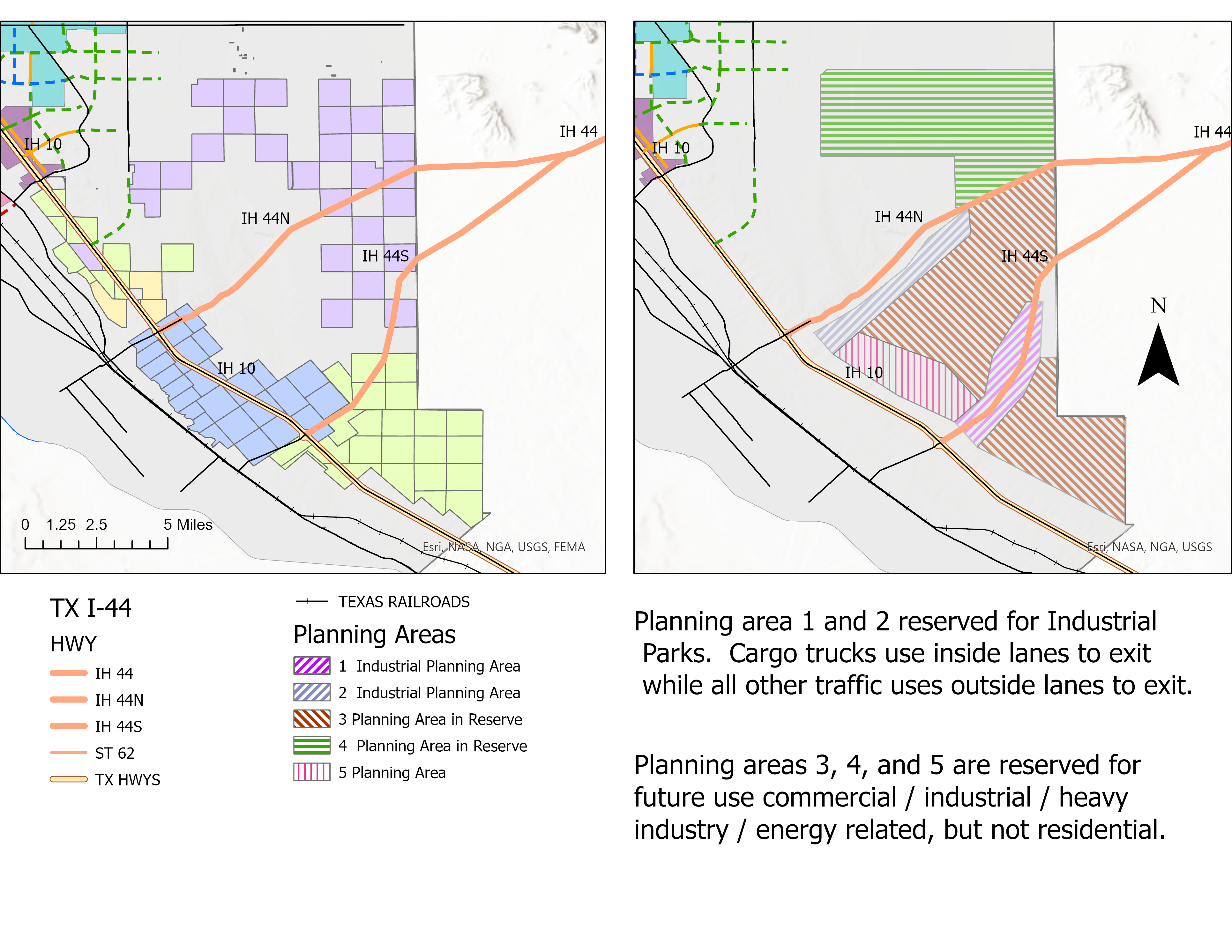
Click map for larger view This boundary created by the split freeway creates a natural inland port of Tornillo. Technically, if this was a large rocky outcrop, the whole area could have been designated a state park. Just because it is not that, does not mean such a large land use could be set aside for the purpose of industrialization. If the highway were two rivers that split as shown on the map, there would be less controversy as to the size of such a large inland port yet there is no outside reason to believe that it is not possible. In this scenario, Industrialized area 1 and 2 would begin the installation areas for industrial parks. Note that one large road,
With the creation of a port comes the creation of a Port Authority which the inland port of Tornillo can host freight shuttle, rail, two interstate freeways, massive industrial land holdings, energy park, and freight truck lanes. This requires a master plan and forward thinking for the next 50 years. Partners include 3 current large landowners, USA, State, County, and local government. Other partners include rail and logistic companies as a few examples.
Sub Element Inland Port of Tornillo Uses
The new frontage roads that begin to create the I-44 corridors will incorporate commercial use outside of the inland port of Tornillo while the inside land will be industrial and parallel the frontage roads. Few access roads will be built and few roads that cross the inland port will be built to return to the other direction.
Sub Element Freight Shuttle
The conventional thinking is to build wide roadways for truck traffic. If a lower capital cost ground level Freight Shuttle can produce better results, then this would be the future for this port. In the future, we look for a ground level freight shuttle utilizing a protected ground level R.O.W. for freight shuttles and rail, multiple freight shuttle terminals, and optional built in freight shuttle service to industrial parks and / or logistical terminals. The opportunity will exist to develop adjoining industrial parks that share a logistical terminal, rail, and freight shuttle service.
Massive truck traffic, using truck only lanes, enter the Inland Port of Tornillo to off load at multiple locations, distances, or company warehouses where a freight shuttle on loads cargo will pass through into Mexico’s inland port of awaiting locations, distances, or company warehouses to offload. This process works in the reverse and considered of a class A secure infrastructure with minimal security stops. Modern logistical warehouses located in every Industrial Park will have loading docks for trucks, trains, and / or freight shuttle that are custom prescreened. The shuttle enters the rail system undisturbed until it reaches another logistical warehouse.
Sub Element Trucks that Never Leave the Highway
I-44 can become the first interstate freeway known for their truck traffic never to leave the freeway. This will keep them on the interstate, minimize wear on city streets, and avoid passenger vehicles. This will begin early with a inland port of Tornillo and I-44 roads, where only one exit side is used for Commercial Motor Vehicles (CMV) while the other exit side is used for passenger vehicles (POV). Generally, CMV go left inside the inland port of Tornillo while POV go right into general traffic roads.
Sub Element Inland Port of Tornillo Energy and Infrastructure
An inventory of energy sources will be mapped as part of our project. Sources may include wind potential, current electrical high-power lines, Natural Gas lines and border crossings, Petroleum Refinery, and Petroleum Product line and terminals. Resources that are not fully developed like wind farms, solar parks, hydrogen production, and energy storage should also be part of the conversation in the development of the inland port of Tornillo.
Because it could take decades to fill both north bound and south bound frontage road / I-44 road abutting industrial and commercial use, a proposed use for interior remote land inside the inland port of Tornillo will host solar parks. To fulfil their capital expenditure rate of return, they are expected to occupy the land for several decades until the need comes to expand the industrial / heavy commercial use of this same land.
Sub Element R.O.W.
Because right of ways will be difficult to obtain in the future, right of way (R.O.W) for ground level freight shuttle inside the inland port of Tornillo will be incorporated into the planning of the inland port of Tornillo from day one. These essential land R.O.W.s will allow for a future freight shuttle or rail to be built inside the inland port of Tornillo. Being ground level, the freight shuttle will save millions of dollars in capital cost and not have to elevate their rail system throughout most of their milage trackage. This freight R.O.W will extend to the border and to the beginning split of I-44. In essence, the I-44 inland port at this location encloses and protects vital freight R.O.W.s
Sub Element Truck Freight Lanes
As done already with Georgia, careful planning of the I-44 lanes around the inland port of Tornillo will allow for only truck lanes important for safety and efficiency. Because the I-44 will first host frontage roads and grow inward into proposed R.O.Ws. and control access, future passenger lanes and freight lanes can be built in this split freeway area. Passenger lanes exit to the right while freight trucks exit to the left into the inland port of Tornillo.
Sub Element Interstate Rail
If the freight shuttle can be expanded to include passenger rail, the time would be in the early planning stages. As much that can be done to widen the split highway from El Paso / Tornillo region to New Mexico border or beyond opens both the possibility to host future freight or passenger rail.
Element Current Landowners
It is by sheer coincidence and fortune that the Fabens / Tornillo split abuts the 11,745 acres of University of Texas Land both north and south of the I-10 boundary. In fact, because of this land ownership, the inland port of Tornillo can extend past the I-10 freeway and be bounded by the UT lands.
Other landowner is the State of Texas, mostly outside of the proposed inland port of Tornillo which can either expand the inland port of Tornillo or become a support land use.
The third largest landowner is Texas Pacific Land Trust which one half of their land is inside of the proposed inland port of Tornillo.
The greatest impact these three entities (portfolio land) can have on the proposed inland port of Tornillo is to keep their land portfolio intact for decades. Leasing the land would protect future development inside and around the proposed inland port of Tornillo while providing decades of future income to these three large land holders. The protection comes from long term investment decisions which private developers may not have the patients for.
While private investment in industrial parks accept long term leases in lieu of purchasing the land, it allows industrial land developers greater investment flexibility knowing the land leases has long term lease arrangements that will not change over time. Long term outlook of this portfolio land allows for orderly planning and execution of incremental infrastructure improvements.
Element Technology Uses
The port authority of the inland port of Tornillo must utilize high impact technology from its inception. AI used for route, logistical efficiency, and planning are just a few examples. High use of I-44 apps for passenger traffic separates from commercial traffic providing important information about and within the I-44 corridor.
Widen split highway is not necessarily a technological innovation but it could be a physical geographic innovation with new advantages that make use of other physical and electronic innovations.
Security built into the physical world and electronic cloud environment from inception. Sometimes the electronic cloud environment has to compensate for physical design when physical design should keep in mind how electronic cloud environment is impacted.
Element Fabens / Tornillo
The proposed inland port of Tornillo would be company to the existing Fabens airport, UTEP Technology Research and Innovation Acceleration Park, UTEP Bravo Site / Unmanned Aerial System Flight Test Range. Both the I-44 and UTEP research facilities would both gain from each other’s presence. I-44 brings more attention to the area while UTEP research facilities begin the industrial land use of the area.
This is the one area excluded in the planning scenario map because it is the only area that has some planning. How much of the UT Land is involved in the planning is unknown. The other land uses would have to account what is already planned in the area and proceed to develop industrial parks along the proposed I-44 inside the inland port of Tornillo.
| GO TO TOP |